
This guide displays two informative images of our area, and details about 10 of our major rock formations. The selector box below will find rock formations by name.
Most of the rocks that make up the Pajarito Plateau are volcanic rocks, which are the products of volcanic eruption. The volcanic rocks lie on top of sedimentary rocks, rocks that are eroded from older pre-existing rocks, transported by water, wind, or ice, and then deposited. The sedimentary rocks are important aquifers for the communities of Los Alamos and White Rock. The rocks on the Pajarito Plateau, from youngest to oldest, are below.
Additional details about our local geology are available in a 3-part series of articles:
The Pajarito Plateau Part 1 – Setting the Stage Daily Post, Jan 2014
The Pajarito Plateau Part 2 – Its Creation Daily Post, Feb 2014
The Pajarito Plateau Part 3 – When White Rock Was a Lake Daily Post, Apr 2014
Subject Area Experts (all guides)
Steve Cary (butterflies)
Beth Cortright (insects)
Terry Foxx (invasive plants)
Leslie Hansen (mammals)
Richard Hansen (fish, mammals)
Dorothy Hoard (butterflies, trees)
Chick Keller (flowers, herbarium)
Shari Kelley (geology)
Kirt Kempter (geology)
Garth Tietjen (reptiles)
David Yeamans (birds)
Web Development and Content Management
Pat Bacha
Jennifer Macke
Graham Mark
Akkana Peck
Contact
Please contact us for local nature questions and sightings. We welcome comments, corrections, and additions to our guides.
For more information about local nature, please visit our Nature Blog or subscribe to PEEC This Week.
Skyline of the Pajarito Plateau

Click to enlarge. Photo: Kirt Kempter
Topography of the Pajarito Plateau
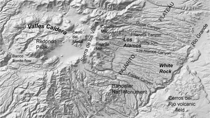
Rock Formations of the Pajarito Plateau
Make Selection
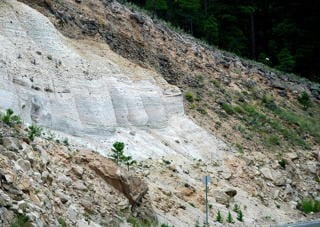 Photo: James St. John | El Cajete PumiceAge: 50,000 years El Cajete Pumice contains small crystals of a black, flaky mineral called biotite which distinguishes it from older pumice deposits. El Cajete Pumice originated from an eruption in the southwestern Jemez Mountains, south of Redondo Peak. While there are thick deposits of El Cajete Pumice in the southern and southeastern Jemez Mountains, there are only two small patches present near Los Alamos, both in Pueblo Canyon. It can be found on mesa tops to the west of the Bandelier National Monument headquarters. |
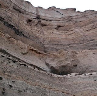 Photo: Shari Kelley and Kirt Kempter 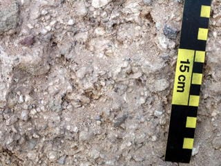 Photo: Shari Kelley and Kirt Kempter | Cerro Toledo IntervalAge: 1.2 million years The Cerro Toledo Interval defines the period between the two big eruptions that produced the Otowi Tuff and the Tshirege Tuff. Volcanic centers in the Valle Caldera were active during this period, producing pumice which the prevailing winds blew towards Los Alamos. These pumices which are interbedded with sand and rare gravel formed as the result of erosion during the approximate 400,000 years between the two big eruptions. |
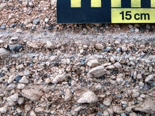 Photo: Shari Kelley and Kirt Kempter | "Golf Course" AlluviumAge: 1.2 million years "Gold Course" Alluvium is made up of loose bands of eroded sediments consisting of pumice, sand, and gravel derived from from the Cerro del Medio Dome inside the Valles Caldera to the west of Los Alamos. This particular pumice is aphyric meaning it is without crystals. The prevailing winds blew the pumice from the Caldera to Los Alamos. The alluvium underlies Western Area, North Community, Ponderosa Estates, the area west of downtown, and the Golf Course in the town site of Los Alamos. One of the best exposures of this unit in Los Alamos is a road cut by Caballo Peak Apartments on the south side of Canyon road. |
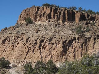 Photo: Akkana Peck 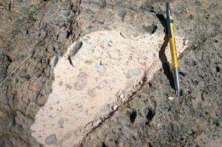 Photo: Shari Kelley and Kirt Kempter | Tshirege Member of the Bandelier TuffAge: 1.25 million years This tuff (light, porous rock formed by consolidation of volcanic ashes) was erupted during the collapse of the Valles Caldera over one million years ago. The eruption began by shooting pumice far into the sky, forming a layer of what is known as Tsankawi Pumice. This pumice contains abundant quartz and sanidine crystals and forms a uniform layer about 3 to 6 ft (1 to 2 m) thick around the Valles Caldera. The exact duration of the eruption is not known, but probably happened over the course of weeks to months because at least five different cooling units have been identified. The town site of Los Alamos, Los Alamos National Laboratory, and portions of White Rock are built on the Tshirege Tuff. |
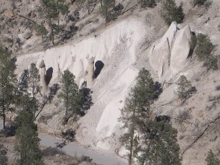 Photo: Akkana Peck 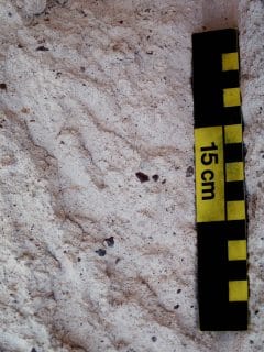 | Otowi Member of the Bandelier TuffAge: 1.6 million years This tuff (light, porous rock formed by consolidation of volcanic ashes) was erupted several hundred thousand years after the Tsankawi eruption. This eruption began by emitting what is known as Guaje Pumice. This pumice is absent on the south, west, and north sides of the Jemez Mountains, but is 6 to 15 ft (3 to 5 m) thick on the Pajarito Plateau northeast of Los Alamos. Like the Tsankawi Pumice, the Guaje Pumice contains abundant crystals of quartz and sanidine. The Otowi Tuff can be distinguished from the Tshirege Tuff in many places by its relatively higher content of black rock fragments. The distribution of the Otowi Tuff on the north side of Los Alamos seems to have been controlled by topography that existed before the Otowi eruption. The older lava domes that form the skyline of Los Alamos (see below) appear to have deflected the Otowi Tuff so that this unit was not deposited north of Los Alamos. For example, Tshirege Tuff sits directly on older rocks in Rendija Canyon, the northernmost Canyon in Los Alamos, to the west of the shooting range. Near the east end of the shooting range, a thin section of Otowi appears. This section of Otowi thickens dramatically in Barrancas and Bayo canyons toward the south. The Otowi Tuff is not present at all in Guaje Canyon immediately north of Los Alamos. |
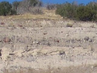 Photo: Akkana Peck | Puye FormationAge: 2.5 million years The Puye Formation is made up of sand and gravel washed off of the Sierra de Los Valles prior to the eruption of the Bandelier Tuff. The gravel is mostly composed of rounded boulders and pebbles made of Tschicoma Lavas. Some of the blocks are huge - the size of a car or small house, but most of the boulders are softball to basketball-sized. This unit is especially well exposed in Rendija Canyon east of the shooting range, but it is also exposed along Highway 502 near the Totavi gas station. The Puye Formation underlies most of the Pajarito Plateau and is an important aquifer. |
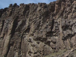 Photo: Akkana Peck  Photo: Akkana Peck | Basalt of White Rock CanyonAge: 2.5 million years Most of the basalt (black, fine-grained dense lava with little silica) exposed in White Rock Canyon originated from vents located in the Cerros del Rio volcanic field located east of the Rio Grande. The explosive interaction of hot basalt with wet sediment underlying the basalt can be seen along the Frijoles trail in Bandelier National Monument. |
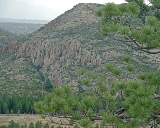 Photo: Mary Carol Williams 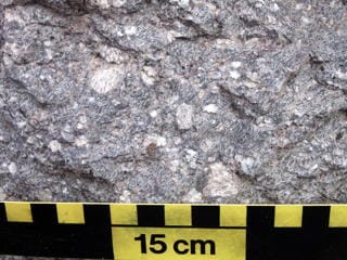 Photo: Shari Kelley and Kirt Kempter | Tschicoma Dacite and Rhyodacite Lava FlowsAge: 3 million years The mountains that form the skyline of Los Alamos, the Sierra de Los Valles, are made up of lava domes and flows of the Tschicoma Formation. The lavas of the Tschicoma Formation around Los Alamos are typically rhyodacitic to dacitic in composition. Most flows traveled less than 6 miles (10 km) from their source and have steep-sided flow fronts. The flows often exhibit block-and-ash features, where overstepped lava flanks cool and collapse into a pile of rubble during foliage. A beautiful example of a block-and-ash flow can be seen in the water gap in Rendija Canyon just to the east of the cemetery in Los Alamos. Three types of Tschicoma Lavas, each coming from a different volcanic center, have been identified near Los Alamos. One center is located on Caballo Mountain to the northwest of Los Alamos. This lava has a streaky appearance, and is lavender to red on weathered surfaces. Phenocrycrysts (well-developed crystals in a fine-grained matrix) of plagioclase, pyroxene, and sparse biotite and hornblende can be seen using a hand lens. Another center is Pajarito Mountain. This lava is light to medium gray to reddish. Phenocrysts of plagioclase, hypersthene, and pyroxene can be seen with a hand lens. The Rendija Lava forms the majority of Sierra de Los Valles; however, the source of these voluminous flows is uncertain. The vent may have been destroyed when the Valles Caldera formed. These lavas are very porphyritic, with phenocrysts of plagioclase, quartz, and trace amounts of biotite, pyroxene, and hornblende. These lavas are massive, with associated block and ash flows. |
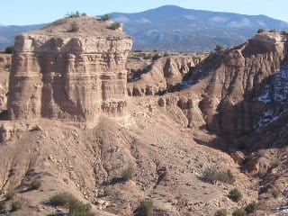 Photo: Akkana Peck | Santa Fe GroupAge: 8 million years The Santa Fe Group is composed of sand and gravel that is largely derived from mountainous areas to the northwest, north, and northeast of the Jemez Mountains. In some places, ancestral Rio Grande or Rio Chama river gravels with well-rounded quartzite, granite, pedernal chert, or volcanic pebbles are preserved. The Santa Fe Group is the pink sediment beneath the gray Puye Formation along Highway 502 near the Totavi gas station. Its pink color is largely derived from the pink mineral orthoclase, an important component of the Sangre de Cristo range. |
Older Jemez Volcanic RocksAge: 8 million years In a few places, old basalt (black, fine-grained volcanic rock with little silica) and andesite (dark, fine-grained, brown or grayish volcanic rock) nearly 10 million years old are preserved in the deep canyons of the Pajarito Plateau. Old basalt is found in Los Alamos Canyon to the west of the reservoir, and old andesite is found near Pine Springs north of Los Alamos. |